AI4Peat Project team members: Anne Williams, Michelle Johnson, Samuel Richardson, Nick Tomline, Martha Tabor, Phil Shea.
Restoring Peatlands
Peatlands are among the UK's most valuable ecosystems, playing a crucial role in carbon storage, water regulation, and biodiversity.
However, many peatland areas have been degraded by historical drainage, erosion, and land-use changes.
Natural England is a key deliverer of the England Peat Action Plan, which sets out the government’s long-term vision for the management, protection, and restoration of our peatlands, so that they provide a wide range of benefits to wildlife, people and the planet. Restoring these landscapes is vital for meeting the UK's climate and environmental goals, but to do so effectively, we need accurate and up-to-date maps of peatland condition.
Traditionally, mapping peatland features such as grips (artificial drainage channels), gullies (natural drainage features) and haggs (steep eroded peat edges), required field visits or manual digitisation, an approach that is both time-consuming and inconsistent across large areas.
The AI4Peat Project
To address this challenge, the AI4Peat project has used artificial intelligence (AI) to map peatland surface features across the uplands of England.
The project won the Civil Service Data Challenge in 2021 with a proposal to leverage deep learning models and aerial imagery to create this map, representing a step change in how we monitor and manage the natural environment.

Using Computer Vision for Peatland Mapping
Our approach harnesses two types of deep learning models to automate this process:
- Semantic segmentation models to detect grips, gullies, and haggs, distinguishing them from the surrounding landscape.
- Object detection models to identify dams to track where restoration has already occurred.
These models were trained using existing digitised data, enabling them to detect subtle landscape features in high-resolution aerial imagery (12.5 cm resolution Aerial Photography for Great Britain) and LiDAR terrain data.
The trained models were then deployed over all areas of England’s upland peatland, producing a national scale map of peatland surface features. This provides a comprehensive and repeatable method for monitoring peatland damage and restoration over time, allowing land managers and policymakers to assess changes and target restoration efforts more effectively.
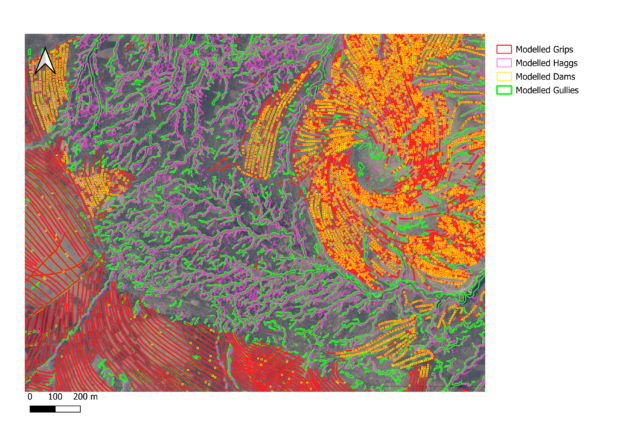
An example of the outputs for an area in the Yorkshire Dales is shown below:
The mapped features support field workers by clearly indicating their locations on the ground.
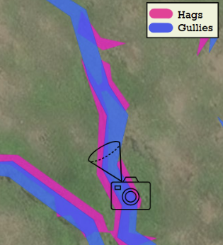
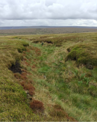
The image below shows an area of hagged peat and gullies in the Peak District, with the features mapped by the models above and the corresponding features on the ground shown below:
Project Partners
Restoration is a time, labour, and cost-intensive process and these datasets will free up time currently spent on mapping, allowing restoration projects to focus their efforts on the actual maintenance and restoration. Through collaboration with the peatland community, we have gathered valuable feedback to refine the datasets to best help restoration teams.
Training AI models requires a substantial amount of labelled data to allow the models to identify features across diverse peatland environments. Peatland partnerships such as Moors for the Future, the Yorkshire Peat Partnership and the National Trust, contributed large volumes of training data.
Collaboration with the England Peat Map team, who coordinated this collection, was essential to the success of the model training, enhancing the quality and accuracy of the features in the final data output.
The project is being supported by Defra's Data Analytics and Science Hub (DASH), Microsoft and Databricks on Defra’s new MS Azure cloud computing DASH platform, which allows complex computation to be done much faster than on a regular computer – an essential requirement for a project dealing with such large datasets. This also makes it possible to easily repeat the process when new aerial imagery becomes available, allowing changes, for example new restoration, to be tracked over time.
The project is also working with the Alan Turing Institute to establish trustworthy assurance and ethics processes for environmental AI projects.
England Peat Map
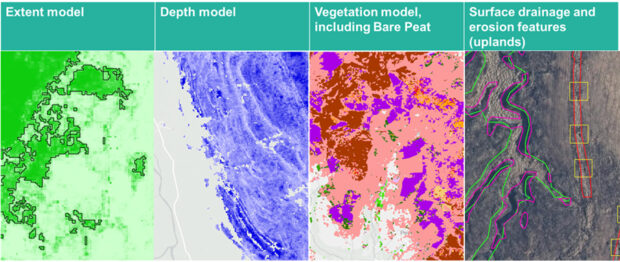
AI4Peat’s outputs will be published as part of Natural England’s England Peat Map, due to launch in spring 2025. This will be the most up-to-date, complete and useable map of England’s peat available.
As well as the peatland drainage and erosion features documented by AI4Peat, the wider map will also show the extent, depth, and vegetation coverage of peat and peaty soils across England.
Future Potential
This project aligns with the UK government’s AI Opportunities Action Plan, which promotes the responsible use of AI to improve public services and decision-making.
In particular, the success of this approach demonstrates how AI can be used to improve the efficiency of environmental monitoring. These types of techniques can be replicated, for example to detect or count animal species of interest, or to track changes in land use or monitor coastal erosion, providing vital insight into how our natural environment is changing and whether policy interventions are working as expected.
The skills, experience, and data pipelines developed during the AI4Peat project can be applied to other use cases across the Defra Group and wider government, accelerating similar AI initiatives. By harnessing Defra's Analytics and Science HUB (DASH), this project enables technical collaboration, supporting more projects like this for enhanced environmental monitoring and the development of computer vision solutions.
Integrating similar AI techniques with other remote sensing data, such as satellite imagery or drone imagery, could further improve accuracy and extend monitoring capabilities across the UK and beyond.
If you have any questions about the project or want to learn more, please contact the AI4Peat team.
Anne Williams – Senior Project Manager – anne.williams@naturalengland.org.uk
Michelle Johnson – Senior Data Scientist - Michelle.Johnson@naturalengland.org.uk
Martha Tabor – Senior Data Scientist - martha.tabor@defra.gov.uk
1 comment
Comment by Nina posted on
Is there any info about when in spring this data will be published? Thank you!