By Alexandra Kilcoyne, Amy Woodget, Anne Stefaniak, Miles Clement, Chris Moore, Sophie Potter and Becky Trippier
A new map that shows the extent and distribution of habitats in England has been launched on 5 April 2022. This probability map, which is freely available to view and use, will provide important data for environmental policy decision making, and can guide efforts to support nature’s recovery. The Living England team tells us more about this highly anticipated product and why its release is so exciting...
What is Living England?
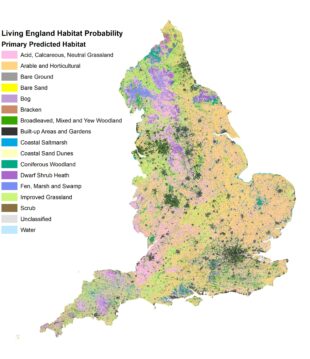
Living England is a multi-year project which delivers a habitat probability map for the whole of England, created using satellite imagery, field data records and other geospatial data in a machine learning framework. The Living England habitat probability map shows the extent and distribution of broad habitats across England, providing a valuable insight into our natural capital assets and helping to inform land management decisions. It is funded by and supports the Environmental Land Management (ELM) Schemes and the Natural Capital and Ecosystem Assessment (NCEA) Programme.
Why are we excited about Living England?
The Living England project highlights the innovation and technical excellence developed within Natural England. The team has broken new ground through the development of complex yet robust workflows operating on a national scale, to provide full coverage of England’s diverse habitats. The habitat probability map uses open-source datasets allowing the publication of this map for the first time under an Open Government Licence (OGL), making it widely available for use in environmental applications. Whilst accuracy varies between different habitats and regional zones, Phase IV achieved an average habitat classification accuracy of 88%.
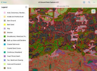
Living England combines expertise in ecology and field surveying with earth observation and data science. The Living England team work closely alongside Natural England field teams to ensure habitat data collected on the ground are compliant with access permissions and provide the models with the right information to inform the habitat classification. As part of the project, they have created bespoke tools including an application to help with targeting the collection of data points to continuously improve the model and mobilise field surveyors to areas requiring further information.
What can it be used for?
The Living England Habitat Probability Map provides an up-to-date prediction of habitat distribution and extent on a national scale for 2021/22. This can be used to help inform a wide range of applications, including...
- Environmental policy decision making,
- National habitat extent and connectivity assessments for targeting nature recovery,
- Assessment of natural capital assets,
- Ecosystem service modelling,
- Updating the evidence base for key policy areas such as ELM.
How do we create the Living England habitat probability map?
The method for producing the Living England habitat probability map was first pioneered by the Defra Living Maps Project in 2016 (SD1705 – Kilcoyne et al., 2017). Since then, the method has grown substantially, allowing us to incorporate a wider range of geospatial datasets and capitalise on advances in data processing and analysis.
The Living England project is currently in Phase IV (2021-22). The method has evolved and is now comprised of several key stages:
- Data acquisition - including Sentinel-1 (radar) and Sentinel-2 (optical) satellite imagery, topography and climate data and habitat data from field surveys.
- Data cleaning - we quality check our training data points to maximise their reliability.
- Segmentation - we employ an object-based method to identify spectrally uniform areas of habitat The segments are then labelled or ‘classified’ into a broad habitat type, using the UKBAP habitat classification, through either a vector-based classification (4) or a random forest machine learning model (5).
- Vector-based classification - some habitats are identified using bespoke data layers developed by the Living England team derived from Sentinel-1 (radar) or Sentinel-2 (optical) imagery processes, or through existing datasets developed by the Defra group (e.g., Arable classified via Crop Map of England from the Rural Payments Agency). This is to maximise accuracy and optimise alignment across Defra products.
- Random forest modelling - all remaining segments are then classified using a machine learning model which assesses the relationship between known habitat types informed by field data and the corresponding characteristics of the satellite imagery and geospatial data layers. This relationship is used to predict likely habitat classes for all remaining segments across England.
- Evaluation – we assess model performance by comparing our predictions against independent data collected in field surveys to compute prediction accuracies across different habitat types and regions.

Where can I access the Living England Map?
You can access the Living England Map on MAGIC WebMap2, ArcGIS Online, the Natural England Open Data Portal, DEFRA Data Services Platform, data.gov. More detail of the methods and data used is available in a technical user guide.
Living England is an ongoing project, which hopes to update the map every two years.
If you have any questions or would like to know any further details, please get in touch with the Living England team at earth.observation@naturalengland.org.uk.
We would love to hear what you think of the map and how you would use the data, please fill out our feedback form here
Thank you... to everyone who has played a part in data collection, method development and publication for Living England. We look forward to continuing our collaborative work and building on our technical achievements as we take Living England forward.
Recent Comments