By Sarah Hammonds, Urban Greening Senior Officer
This blog discusses the launch of two new tools: the Index of Multiple Environmental Deprivation (IMED) and the Environmental Equity Index (EEI). Built collaboratively over 18 months, they map environmental pressures and health inequalities across England, helping decision-makers target green infrastructure investment where communities face the greatest combined environmental, socio-economic and health challenges.
At Natural England our work is driven by a commitment to connect people, place and nature and we’re delighted to launch two new tools that help focus action where it matters most.
After nearly 18 months of collaborative work, Natural England, alongside the Environment Agency and partners across the environmental, academic and public sectors, is delighted to launch two new national datasets: the Index of Multiple Environmental Deprivation (IMED) and the Environmental Equity Index (EEI). I wanted to explain what these tools are, why they were developed, and why we think they matter.
Launching on 22 June, during London Climate Week, felt right for tools that are fundamentally about understanding where the pressures of a changing climate land hardest and on whom.
What do IMED and EEI actually do?
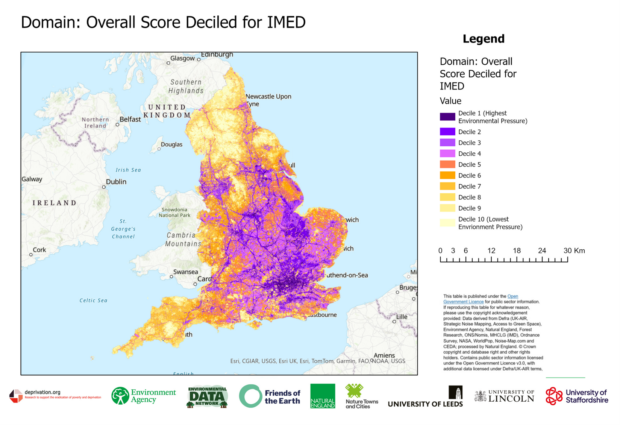
IMED maps cumulative environmental pressures across all of England at 100-metre grid resolution, with the ability to aggregate results to other geographic and administrative levels. It draws together indicators including air pollution, flood risk, environmental noise, habitat deficit, access to green space and climate-related pressures into a single consistent score. Think of it as the environmental equivalent of the Index of Multiple Deprivation - a way of seeing, at a glance, where environmental disadvantage is greatest.
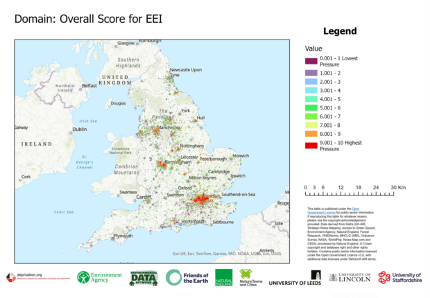
EEI builds on IMED specifically within urban areas. It layers in additional factors such as Urban Heat Island effects, lack of tree cover, years of life lost and wider socio-economic deprivation data. The result is a picture of where environmental pressures and vulnerable communities overlap, what we've been calling "triple jeopardy": places where environmental, socio-economic and health challenges all accumulate at once.
Used together, these tools give decision-makers something they haven't had before: a consistent, transparent, high-resolution evidence base covering the whole of England.
How these tools were built
This has been a truly collaborative project. Natural England worked alongside the Environment Agency, Friends of the Earth, deprivation.org, the Environmental Data Network and academic partners at the Universities of Leeds, Staffordshire and Lincoln, with contributions from Defra. Development ran from 2023 to 2025, we piloted the tools with local authorities, health bodies, planning organisations and NGOs before launch. Therefore, we know what we've released is practical and ready to use.
Natural England's expertise in green infrastructure, spatial data and nature-based solutions shaped how these tools were designed and what they measure. IMED's inclusion of habitat deficit and green space access reflects the kind of evidence base that has long been missing from environmental planning conversations.
How they connect to wider priorities
Both tools support the government's Plan for Change, the Environmental Improvement Plan and Local Nature Recovery Strategies. They're designed to help partners prioritise resources and investment where they deliver the greatest benefits for communities and nature, and to embed nature into planning and development from the outset. Data from the maps provides a strong foundation for developing a Green Infrastructure strategy, an essential step towards achieving Nature Towns and Cities accreditation.
How to use them
Both tools are now freely available via Natural England's Green Infrastructure Mapping Tool. We'd especially encourage local authorities, planning teams, health bodies and community organisations to explore the maps. Look up the areas you work in, export the relevant data, and use it to support evidence-based discussions and decisions on where green infrastructure investment will have the greatest impact. To get the full picture, the best insight comes from combining this data with local knowledge.
This launch is the beginning, not the end. The tools are designed to support decisions, not prescribe them and they will improve the more they're used. If you have questions, find something surprising, or want to discuss how they might apply to your work then we'd very much like to hear from you.
Scan the QR code to explore your area:

Autumn webinars
Webinar | Better Evidence, Better Tools, Better Outcomes: Green Infrastructure Webinar at 10:00-11:30am on 29 September.
Join Natural England and partners from the Environment Agency and the Forestry Commission for an update on a powerful new suite of green infrastructure tools designed to help planners, local authorities and policymakers deliver quality green infrastructure where it’s needed most.
Whether you're a planner, ecologist, public health professional, local authority officer, developer or simply passionate about making where you live greener and healthier, this is the webinar for you. Come along, get inspired and leave with the tools and evidence to make it happen.
Register here.
Webinar | Deep Dive into IMED, EEI Green Infrastructure Mapping Tools at 2:00-3:15pm on 6th October.
Want to get more from the new environmental mapping tools? Join us on 6th October for a practical deep dive covering the latest improvements to the Green Infrastructure Mapping Tool, a walkthrough of Indices of Multiple Environmental Deprivation (IMED), and the Environmental Equity Index (EEI). Whether you're new to the tools or already exploring them, this is your opportunity to build confidence and ask questions
Click here to find out more and register.
Recent Comments